Arranmore Island is situated in the Atlantic ocean off the West Coast of Ireland in Co Donegal. It’s the largest inhabited Irish Coastal Island with a population of 500 (holiday population is 1000 so to see it at its best go during term time). It’s part of the Gaeltacht with 2/3 of the population being native Ulster Irish Speakers. Access to the Island is from Burtonport via the Blue Ferry Service and the Red Ferry Service. Booking for a camper van involves phoning instead of a simple book by app as size comes into consideration and the cost is £60 return.
When we arrived at the port after a very pleasant run from Dungiven through Co Donegal (70 miles, 1 hr 50mins, we continued to battle the chasers looking to contact Nobby MM0UKI on Rockall and I was lucky to get through on the mobile as we waited in the harbour. Despite me asking him to take a call from Ian the request wasn’t picked up due to the “over exuberance” of other callers. (Ian did manage to make contact when we returned home.)

After a short wait which we used to walk the dogs, the very pleasant and helpful ferry team “packed” all the vehicles themselves so that every inch of space is used. I had booked to allow for a trike carrier which we didn’t actually bring but as is turned out wouldn’t have fitted as when the ferry ramp was closed it was touching the bumper of our van in front and the rear was tight against the car behind!
If you are like me and look at the ferry track on google maps and thought this has to be a mistake for this journey as it seems to go through land – there is a very narrow channel between smaller islands just off Burtenport that the ferry just fits through. Indeed, the company’s newly commissioned ferry is being specially built in Scotland as new standard builds for Calmac are too wide.
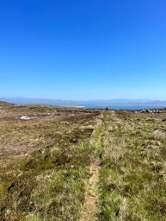
The weather was amazing (clear blue skies) which made for amazing colours on the sea as we travelled over. One of the ferrymen kindly pointed out various landmarks on the wee-er islands and gave us some information that we hadn’t expected – all the major roads on the island had just been tarmacked – so all the potholed journeys we had expected were not to be. After following his instructions and getting through some very narrow junctions with the campervan we arrived at the start for our walk up to Cluidaniller West Top (Cnoc an Iolair mullach thiar) (Hill of the Eagle) which I will just call Arranmore for easiness of writing!
Most of you are familiar with the SOTA program – Summits on the Air – but for those of you who aren’t: every Marilyn around the world in participating countries can be climbed for points (10 for the highest, 1 for the lowest) to be gained by the activators and chasers both. Arranmore has a reference EI/IN-092, 1 point. WABers and WAIers are important chasers for us as they often guarantee the 4 contacts needed for the points.


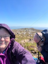
So it was beautiful sunshine when we left the camper but there was a very strong breeze which made it quite cool so Poppy and Roxy were left in the van to sleep. They are 14 and 15yrs old now so get cold on summits even with coats and blankets. Trig point baggers will realise that the main tracks to the summit go to the East top where the trig is but this isn’t the true summit which is the west top where we were heading. (The dip of more than 25m between the 2 tops means the trigpoint is ineligible for SOTA). For about half a mile there is a cart track and then when you see the summit cairn just head for that over patchy heather and rocks. It’s a gentle climb but very awkward for unstable knees. On arrival at the cairn we set up the gear. HF – KX2, 5-10 W, linked dipole for 20m and 40m. VHF is FT60 4W hand held, Tactical antenna for UHF/VHF and a portable 2m beam as we had arranged a few skeds with Phil EI9KA on Minaun EI/IW-035 on Achill with 2m – at nearly 100miles this would be a really good contact! After a summit to summit with Martin on GW/NW -041 on 40m whose spot we had just noticed we went to 2m and had a few contacts with local ops and John GI4OSF in Ballymoney. We had a chat with Phil on Achill on both VHF and UHF so success! After getting enough contacts on 2m and 70cms to qualify I moved to 40m SSB and CW to get a total of 30 contacts including WABers G0FVH, G0FEX, 2R0FLW and fellow SOTA ops EI6FR, F/G0WML and G4OBK. Ian tackled 20m but it wasn’t as productive. We then took time for a snack and photos before heading off the hill.


A small hill with amazing views out over the Atlantic and fantastic take off for our radios. 1 mile (1.6 k) return with only 36m height to climb (20mins with all our radio gear and my dodgy knees!).


That evening as we sat at the Beaver Island Monument which is in Lough Shore drinking a glass of wine watching the sunset there was a very interesting discussion on the SOTA reflector about the use of EJ prefix for Irish Amateurs on Irish Islands which got very heated- suffice as to say I was just glad we chose the correct option!


The following day after a leisurely breakfast and dog walk we headed down to the light house which is perched above the cliffs on the northwest of the island on a promontory that isn’t the most northerly nor the most westerly but 2nd best! We had come here to activate Arranmore Cliffs for the WWFF programme. A more beautiful place than you could ever imagine!
The light house is locked up with a high wall and gate – disappointing as there is a geocache beyond the wall. There are a set of steps at the wall that go down the cliffs to the sea very steep, slippery and dangerous! There is also a ruined coast guard station occupied by sheep and up the hill a WW2 Eire 75 sign to warn pilots that they were over neutral Ireland.


With WWFF activations researching the activation location is very important but Arranmore cliffs was reasonably easy as the boundary comes up to the road and there are several places where you can pull over as there are few fences on this side of the island – just be careful of the sheep and sheep **it.
Conditions weren’t great but by lunchtime there were over 50 in the log so we packed up and headed to the south of the island for lunch at another amazing viewpoint before heading down to the ferry port. On the way we passed 3 schools including a secondary school – surprising for an island of this size, but we discovered later when chatting to the ferryman that because it is a Gaeltacht children come from the Mainland to be taught in Irish.
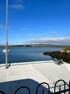
The ferry was leaving at 3pm so we arrived at the port slightly early but in plenty of time for a post activation ice cream. Not quite the quality of “Pinkerton’s Shap” but delicious all the same! The same operation took place at the ferry with the crew packing in as many cars as they could with spaces for the walking teachers and schoolchildren going home. (in termtime the 3pm ferry is really 3:20pm to let the kids get home!) Again, we travelled under amazing blue skies but there was much more of a swell on this return journey.


Arranmore is an Island I would visit again – breathtakingly beautiful scenery all easily accessible. Not as much to do in term time if you are into eating out/trad music but in holiday time there seems to be something on every day and a Country Music festival in August #keephercountry!
